I have been out of state all week due to a family medical emergency so this is going to be a short report. Hopefully I will be here this week to get the information for the next report.
The water is hot but the fish didn’t care at least a couple of the days. The Kings turned on Sunday and again Tuesday per reports I got from a couple of our locals. Dylan and Johnnie S. decked three of the five fish Sunday. One of Dylan’s fish was 14 pounds, another fish decked was 15 pounds and Johnnie’s fish was 20 pounds. The Tuesday Brandon decked a nice King. His fish was one of about 15 to hit the deck. According to reports, numerous other fish were hooked but lost. Here are a few pictures shared with me:

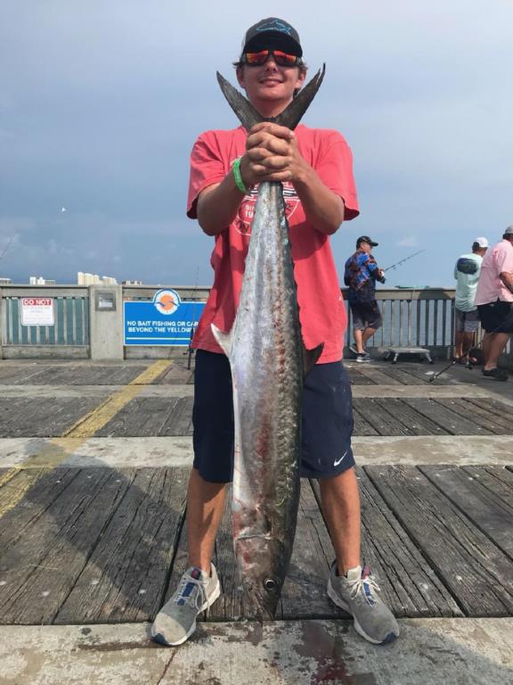
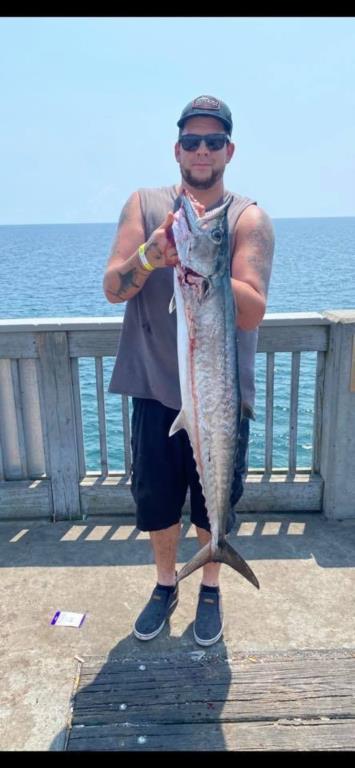
The attached weather forecast is almost certain to change due to the Trpoical Storm brewing. Fred is supposed to head our way by Sunday or Monday. BE sure to keep a watch on Fred as he decides where he will make landfall.
Water temperature: 86-88.2
|
|
MM | DD | TIME
(EDT) | WDIR | WSPD
kts | GST
kts | WVHT
ft | DPD
sec | APD
sec | MWD | PRES
in | PTDY
in | ATMP
°F | WTMP
°F | DEWP
°F | SAL
psu | VIS
nmi | TIDE
ft |
08 | 11 | 8:12 pm | E | 1.9 | 1.9 | - | - | - | - | 30.11 | - | 82.0 | 88.2 | - | - | - | - |
08 | 11 | 8:06 pm | - | 0.0 | 1.9 | - | - | - | - | 30.10 | - | 81.5 | 88.2 | - | - | - | - |
08 | 11 | 8:00 pm | NNE | 1.0 | 2.9 | - | - | - | - | 30.11 | +0.01 | 80.8 | 88.2 | - | - | - | - |
08 | 11 | 7:54 pm | NNE | 2.9 | 5.1 | - | - | - | - | 30.11 | - | 79.7 | 88.2 | - | - | - | - |
08 | 11 | 7:48 pm | NNE | 4.1 | 8.0 | - | - | - | - | 30.11 | - | 78.4 | 88.2 | - |
|
|
|
https://tides4fishing.com/us/florida-west-coast/panama-cityngin g
Full Moon Sunday Aug. 22, 2021 New Moon Monday Sept. 06, 2021
Tides for the upcoming week:
Sunrise: 554am Sunset: 7:25pm
Thursday 12th. 5:54am Low 0.9 3:37am High 0.9
8:51pm Low 0.8 1:51pm High 1.3
Friday 13th. 9:00am Low 0.8 3:21am High 1.1
7:37pm Low 0.9 3:36pm High 1.1
Saturday 12:18pm Low 0.7 2:54am High 1.3
Sunday 3:17pm Low 0.4 3:04am High 1.5
Monday 4:13pm Low 0.2 3:48am High 1.7
Tuesday 5:05pm Low 0.0 4:53am High 1.8
Wednesday 18th. 5:56pm Low -0.1 6:21am High 1.9
Sunrise:6:11am Sunset: 7:19pm CDST
The Marine forecast for the next several days is:
FRIDAY
Northeast winds 5 to 10 knots becoming southeast 5 to
10 knots in the afternoon. Seas 2 feet. Dominant period 5 seconds.
Protected waters a light chop. Chance of showers and
Thunderstorms through the day.
FRIDAY NIGHT
Northeast winds 10 knots. Seas 1 to 2 feet.
Dominant period 5 seconds. Protected waters a light chop. Chance
of showers and thunderstorms in the evening, then slight chance
of showers and thunderstorms after midnight.
SATURDAY
East winds 10 knots. Seas 2 feet. Dominant
period 4 seconds. Protected waters a light chop. Chance of
showers and thunderstorms.
SATURDAY NIGHT
East winds 10 to 15 knots. Seas 3 feet.
Dominant period 4 seconds. Protected waters a light chop. Chance
of showers and thunderstorms.
SUNDAY
Tropical storm conditions possible. East winds 15 to
20 knots. Seas 4 to 5 feet with occasional seas up to 6 feet.
Dominant period 5 seconds. Protected waters a moderate chop.
Chance of showers in the morning. Chance of thunderstorms through
the day. Showers likely in the afternoon.
SUNDAY NIGHT
Tropical storm conditions possible. Chance of
showers and thunderstorms.
MONDAY
South winds 15 to 20 knots. Seas 5 to 6 feet with
occasional seas up to 8 feet. Protected waters a moderate chop.
Chance of showers and thunderstorms.
local forecast)
FRIDAY (89/76 rain 24% wind ESE-06)
SATURDAY (91/77 rain 53% wind E-07)
SUNDAY (89/76 rain 63% wind E-10)
MONDAY (87/78 rain 41% wind E-11)
TUESDAY (88/78 rain 40% wind SSE-09)
WEDNESDAY(89/78 rain 39% wind SE-08)
PIER MANAGEMENT CONTACT INFORMATION:
Bay County Parks and Recreation – 5304 Majetti Tower Road Panama City, FL 32404
850-248-8730
Travis Barbee – Bay Co. Parks Division Manager – tbarbee@baycountyfl.gov – 850-381-8155
James Beattie – Bay Co. Beach Operations Manager - jbeattie@baycountyfl.gov - 850-814-3771
Tight lines and screaming drags,
Sam